Sometimes revisiting old, familiar memories can lead to an innovative solution, as is the case with the Innovation Center’s client CartoFusion Technologies.
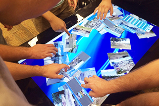
Founder and president, Dr. Richard Smith is preparing for the launch of the application known as SituMap: a mapping tool that allows multiple, simultaneous users to view, create and share multiple layers of information on one screen.
For over a year now, CartoFusion Technologies has been developing a mapping application that could be utilized by first responders.
“Texas A&M University-Corpus Christi (TAMU-CC) Police Chief Alan Gutierrez, who has been in the business for 30 years, says he was looking for a tool that he could use every day and not only during emergencies,” states the StateTech article “University Professor Develops Mapping App for Public Safety.”
In an article from UAS Magazine titled “Powerful UAS app draws inspiration from movies, toys, games” Smith talks about how he drew inspiration for the app from his childhood, mainly from Matchbox cars, World War II movies and computer games.
“’They had the big maps and pushed around little aircraft carriers with sticks’” Smith is quoted as saying in that same article. “’I was thinking a digital war table like that would be cool. It was a way to combine the physical interaction with the digital.’”
SituMap was created to address the problems that map creation and spatial exploration was not intuitive and required extensive training. However, unlike its competitors, SituMap is distinct in two areas: it allows for multiple users simultaneously and it’s easy to learn.
Now, after months of research, programming and discussions with early adopters CartoFusion Technologies is gearing up for the release of SituMap 1.0 in January 2016.